RIS-Italy Project (Stage 2)
The Project “Study for the standard enhancement and interconnection of National System of RIS-Italy” (Action no. 2014-IT-TM-0319-S) is the second stage of the Global Project related to the development and exploitation of the Northern Italy Waterway System (NIWS). In particular, this Action aims to support the evolution of the RIS-Italy System by completing the functionalities of the existing prototype, extending the radar coverage to the entire NIWS and promoting further technological development in order to make inland navigation more attractive.
Introduction to the NIWS Global Project
The Global Project, consisting of the completion of the system of infrastructures for waterway transport from Milan to the ports of the Adriatic Sea, and the extension of navigation on the Po westward, is a fundamental part of an overall and shared policy for the development of the whole Northern Italy economic area.
Reducing the negative transport impacts on environment and enhancing the aspect of inland waterways as backbone for a new concept of intermodality, it will improve the industrial competitiveness of the area, re-launch some economic and transport sector today in a critical situation and increase the development inland navigation, rail transport and of Adriatic seaports as gateway to the Padana Valley with its link with European Corridors.
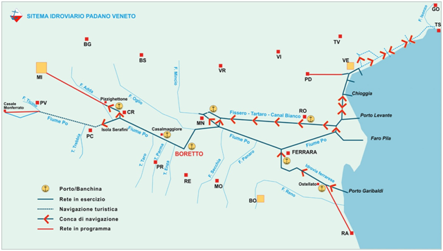
Figure: Northern Italy Waterway System
The main objectives of the Global Project are the following:
- To improve the traffic capacity and efficiency of existing infrastructure, promote the waterway transport and implement safety through the development of advanced information systems;
- to promote the system of freight transport and logistics through the waterway system Padano-Veneto at the top of the national offer of inland waterway and tidal water and strengthen some important nodes of the transport network infrastructure;
- to implement a multimodal project, enhancing intermodality to benefit environmentally-friendly transport systems (waterways, sea and rail) shifting freight transport from road to rail;
- to implement and promote a sustainable transport systems to meet the objectives set out in the White Paper 2011 “Roadmap to a Single European Transport Area – Towards a competitive and resource efficient transport system” and contribute to the achievement of the targets set by the European Commission in terms of modal shift and emissions.
- to develop a ‘greener-oriented’ transport system, ensuring an integrated and sustainable European transport system for goods, recommending a concrete “corridor greening development plan”.
- to eliminate bottlenecks, introduce new technologies and Intelligent Transport Systems (as for example RIS navigation systems), in the European waterway network;
- to enhance the competitiveness of the European and Italian economies by offering the advantages of inland water transport: reliability, safety and reduced costs (financial and external costs).
There are also very important objectives of the Global Project that will be achieved at local level (Italian level):
- reduction of road traffic congestion and CO2 emissions caused by road transport in the Po River System, one of the most industrialized and polluted areas of Europe, thanks to a modal shift from road transport to the more environmental friendly waterway mode.
- Development of the key concept of “Multimodality” in general, and Northern Italy IWW network, underlining Mantua, Cremona and Rovigo logistics activities in the North-East area keeping nevertheless its barycenter inside the central Italy, near Milan, bringing added value and enhancing concerned areas from the real estate point of view.
- contribution to the development of Adriatic seaports by extending their hinterland, in particular to inland ports (Rovigo, Mantua, Cremona and Milan in future) in order to conceive inland ports as back ports to solve problems related to customs clearance and make real tax warehouses.
Main objectives of RIS-Italy Project
The main objective of the Italian RIS is to create the conditions for a better and smoothest use of the Italian inland waterway (adaptation to the standard components such as NtS, LMS, HD, ERI, IENC) increasing the safety of navigation and the efficiency, aligning, in the meantime, the community of users and Institutions involved (Region, Provinces, Agencies, Firebrigades, Civil Protection, etc.) through a sharing of information easily accessible.
During the first stage of the RIS-Italy (Action 2010-IT-70203-S “Studies for the development of the RIS operability along the Northern Italy Waterway System”) it has been demonstrated the full potential of the RIS system in terms of increased navigation safety and capacity in traffic flow management (pilot prototype compliant with the functional requirements).
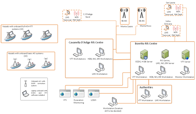
Figure: RIS-Italy Prototype
Having in mind the full implementation of an operational RIS service and also taking into account the promotion of further actions as a follow up of RIS-Italy, a set of recommendations have been provided:
- Concerning the adoption of the Directive 2005/44/CE, it would be necessary to proceed with national and regional authorities organizing, in particular, meetings with:
- Ministry of Infrastructure and Transports
- Commission IX of Transports of the Italian Parliament
- Intesa Interregionale, the coordination body for the waterway whose members include Piemonte, Lombardia, Emilia Romagna and Veneto Regions, that operates directly with ports and infrastructures, planning infrastructural works according to available resources.
- The Agreement among the authorities identified to manage the RIS system, already firstly elaborated, has to be edited and signed.
- Essential to the system implementation, training courses to the use of the RIS. Three courses have been already realized (activity in process)
- A further analysis in depth of the possible integrative modules is recommended with particular attention to:
- Logistic Services
- Leisure vessel, tourism and relative added value services
- Interfaces with National Single Windows and Port Authorities systems
- It is recommended to introduce AIS carriage requirement using at least Class B also for small vessels and leisure boats, in order to make them tracked for traffic management purposes and to better exploit the automation offered by the river information services (e.g. locking process). Alternatively, passive acoustic systems might be installed along the waterways thus avoiding mandatory AIS carriage onboard all inland waterways vessels.
- The interoperability with the National Maritime Single Window is strongly envisaged, especially to promote the introduction of new trade and operational services from the business and port sectors’ perspectives.
Taking into consideration these recommendations in order to have a full operational RIS Service, a second phase Action is presently under development in order to complete the functionality of the existing prototype and, at the same time, to develop additional technology issues to increase the traffic of vessels using the inland waterways.
The present action is structured to cover three main functional areas (Inland ECDIS and NtS upgrade, Safety improvement for the NIWS and Inland-maritime integration). Special attention has been paying to the inland-maritime integration, where a specific system test will be carried out in order to demonstrate the envisaged benefits from the on board perspective.
In particular, the action consists of the following macro-activities:
- Activity 1: Project management, communication and dissemination
- Activity 2: Inland ECDIS and NtS Upgrade
- Activity 3: Safety Improvement for The Northern Italy Waterway System
- Activity 4: Inland – Maritime Integration
- Activity 5: System Test For Inland – Maritime Integration
Project Activities
The project will be realized trough 5 main activities, each of whom will be managed by one or more partners.
ACTIVITY 1 – Project management communication and dissemination
It will deal with both the administrative/financial management of the project and its dissemination strategy.
ACTIVITY 1.1 – Project Management
The project management activities include:
- The Project management and coordination;
- Kick-off event organisation and implementation;
- The administration of the financial resources of the project and timely execution of all payments to partners, in line with the project budget and contractual obligations;
- The continuous monitoring and evaluation of the progress of the planned activities of the project, workplan and tasks;
- The continuous monitoring of information flows;
- The preparation and submission of all administrative and financial reporting in compliance with the contractual rules and obligations;
- The organisation and enforcement of quality control procedures;
- The adoption of risk management measures as appropriate.
ACTIVITY 1.2: Communication and Dissemination
The communication and the dissemination activities will be articulated in the following measures:
- Set up and publishing of a website;
- Local stakeholder communication strategy;
- Transnational cross fertilisation with similar projects in the EU;
- Effective communication interfaces and dissemination channels, with events, publications, participation to seminars and events at local, national and EU level;
- Non media dissemination materials (leaflets) describing the project objectives, the pilot activities and expected outcomes in a concise way;
- Media coverage of the project;
- Raise awareness campaign towards inland and sea ports, relevant public authorities and policy makers in the programme area;
- Prepare a Final public event;
- Final multimedia dissemination output.
ACTIVITY 2 – Inland ECDIS and NTS Upgrade
It will produce bathymetric IENC cells to be implemented in the existing IENC already installed on the ships involved in the 2010-IT-70203-S Action and will integrate these cells to RIVUS application. Besides, this activity will upgrade the NtS service by means of web services, in order to allow a completely autonomous information flux between RIS provider and users, creating a “two way” communication system.
ACTIVITY 2.1 – bIENC implementation in IENC
This project has to improve the existing data set with new elements and contents. According to the publication of the Inland ENC Harmonization Group “The European R&D IRIS Europe 3” of 27th November 2014, in which the use of bathymetric data inside IENCs has been successfully tested, AIPo decided to implement this kind of data inside the NIWS IENC. This kind of information is fundamental during low discharge periods or after important flood events which may lead to strong variations of the channel morphology. The bathymetric data will be produced directly by AIPo by means of multibeam technology surveys, and will be used to produce bathymetric IENC (bIENC) cells.
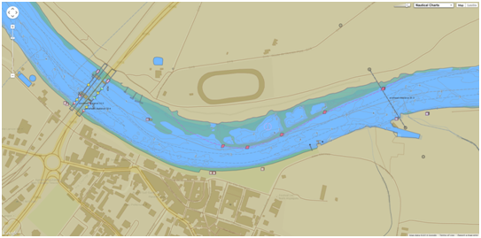
Figure: Nautical Chart
The use of bathymetric ENCs is considered optional. Applications using this approach should have the capability to switch on/off the bathymetric ENCs. The application should indicate when the function is turned on. The content of bathymetric ENCs is limited to the bathymetry data only.
ACTIVITY 2.2 – Integration between RIVUS and bIENC
The RIVUS application developed within the action “Studies for the Development of the RIS Operability along the Northern Italy Waterway System” (2010-IT-70203-S) already includes a database storing charts in the IENC standard format. Existing RIVUS modules (chart database, chart server, GIS) will be updated to benefit from the introduction of bIENC charts in the system.
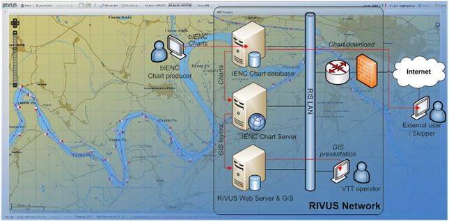
Figure: lRelation between RIVUS and operators/users
The diagram displays the relations between these RIVUS modules and operators/users, where black lines show the physical connections and red lines represent logical flow of data.
ACTIVITY 2.3 – NtS evolution by means of web service
The web-service interface should be adopted as the new NtS standard. This kind of innovation allows the completely autonomous information flux between RIS provider and users, creating a “two way” communication system instead of the present “one way”.
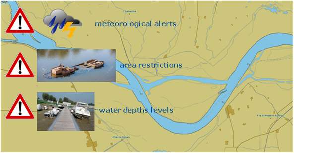
Figure: NtS Evolution
The NtS web-service feature will comply with the specification emitted by the Federal Waterways Engineering Service Centre Information Technology of the BMVBS (DLZ-IT BMVBS), version 1.0.3.0, or as amended in future version of the standard. Such as, all the NtS messages published by the RIS operators using the RIVUS web user interface, will be available for distribution through the web service.
ACTIVITY 3 – Safety Improvement for the NIWS Coordinator
It will develop a Mobile version of the RIVUS application in order to improve the navigation and safety of the little boats.
ACTIVITY 3.1 – RIVUS Mobile Development
The inland navigation safety can be improved by a mobile application (commonly called “App”) which will make available on smartphones or tablets all the functionalities of the RIVUS System. The RIVUS App will be developed for Android mobile platforms and, starting from the locationing device of smartphones or tablets, will provide the following features and information:
- Real time water levels information coming from the NIWS gauges network.
- Navigation locks status, together with the possibility to book the ship passage and knowing the wait time
- Fairway condition, for example dredging areas, presence of hydraulic works areas or limited navigation conditions
- Shallow water cross sections or reaches along the navigation channel
- Notice to Skippers
- Your own position, and the position of all the skippers using the same application, on a suitable cartographic layer
- The position, the navigation track and the velocity of commercial ships equipped with AIS
ACTIVITY 3.2 – RIVUS Mobile web service
This sub-activity will cover all the tasks related to the design and implementation of additional or improved web services, or of other convenient technologies, to allow the RIS centres and the users to exchange information through the RIVUS platform and App.
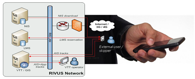
Figure: Relation between RIVUS and mobile App
The diagram displays the relations between the enhanced RIVUS modules and external users exchanging data with the RIS centres using the mobile App, where black lines show the physical connections and red lines represent logical flow of data.
ACTIVITY 4 – Inland Maritime Integration
It will realise the integration of data between the RIS and the maritime informative systems in term of safety of navigation and logistics integration.
ACTIVITY 4.1 – AIS involved Authorities armonization
This sub activity will consist in the review of the organization of the reporting in the inland waterway, to standardize the format and structure as by Directive 2010/65. The Directive 2010/40 on Intelligent Transport Systems (ITS) will also be taken into account referring to road/rail systems and their interfaces with the other mode of transport (e.g. inland waterways).
In inland ports different type of ICT tools exist but they are often not connected with each other and more often not harmonised with River Information Services. In order to increase effectiveness and competiveness in this task the Integrated between Inland Port Information Management System, Logistics Data Systems will be studied. Close cooperation will be realised with all inland port stakeholders of multimodal logistic chain in the considered area. Conclusion on the useful RIS services for the benefit of operations in inland ports will be drawn and recommendations and best practices will be elaborated.
ACTIVITY 4.2 – Functional Requirement for RIS and NMSW Interface
This sub activity will study the interdependence between RIS and the National Maritime Single Window (NMSW) and the necessary actions. Any connections between RIS and the information system of the Customs and Monopolies (AIDA) will be evaluated.
The sub activity will analyse the structures of these two systems and elaborate an Action Plan of the activities necessary to match them and will define the functional requirements for RIS and NMSW interface.
In particular, the required formalities related to ship arriving in or departing from ports and their relevant data contents will be examined to identify which sets of data may be exchanged between the systems through an interface, properly implemented to adopt the principles set at EU level by the relevant directives and by EMSA’s NSW prototype.
ACTIVITY 4.3 – Functional Requirement for RIS and SafeSeaNet Interface
This sub-activity will study the interdependence between RIS and the SafeSeaNet system and all the necessary actions to harmonize these two systems. The SafeSeaNet is a vessel traffic monitoring and information system, established in order to enhance:
- Maritime safety
- Port and maritime security
- Marine environment protection
- Efficiency of maritime traffic and maritime transport
The sub activity will analyse the structure of these two systems and elaborate an Action Plan of the activities necessary to match them and will define the functional requirements for RIS and SafeSeaNet interface.
ACTIVITY 5 – System Test for Inland-Maritime Integration
It will demonstrate the integration of inland and maritime services, with a view to reduce possible issues related to mutual interference and to develop shore based services of common interest avoiding duplication of installations.
ACTIVITY 5.1 – Automatic switching of inland/maritime mode of on-board AIS
The objective of this sub-activity is to complement the functionality of the on-board inland ECDIS software with the following features:
- Detection of events related to vessel entrance in areas under the jurisdiction of the maritime authority or in areas covered by RIS;
- Notification of event occurrence to the skipper through information displayed on the ECDIS;
- Automatic switching of AIS device to maritime or inland mode, depending on the area entered.
The sub-activity will include the following tasks:
- Definition of the areas where inland and maritime modes are required for the on-board AIS;
- Design and implementation of the software module which detects access to the above defined areas and interacts with the ECDIS and the AIS device to display the entrance events and to switch the AIS mode as relevant.
ACTIVITY 5.2 – Transmission of DGNSS corrections using AIS base stations
The sub-activity will include the following tasks:
- Study to optimize the placement of DGNSS reference stations in order to minimize costs and grant the 1 meter accuracy in all the identified areas where this is needed;
- Study to identify the AIS base stations (inland and maritime) for the DGNSS transmissions to cover all the above identified areas;
- Definition of intervals of DGNSS transmissions from AIS base stations to avoid accuracy degradation without impacting on AIS channel loading;
- Implementation of DGNSS transmissions using the AIS stations of the VTT
ACTIVITY 5.3 – Exploiting redundancy of maritime and inland AIS network
Given the relevant geographical overlapping of the areas of interest of maritime and inland services, and the use of standard and compatible AIS technology in both systems, it is practical to implement a communication link between the two systems, with the following advantages:
- the AIS networks may complement each other whereas Base Stations of one system provide additional or better coverage than the Base Stations of the other one;
- the AIS networks may act as mutual failover systems whereas Base Stations from one system provide coverage which overlaps that of the Base Stations of the other one.
- reliability and coverage of both inland and maritime AIS network may be enhanced while saving on cost and number of installations at the same time.
The sub-activity will include the following tasks:
- Design and implementation of the communication link between the maritime and inland systems to grant a mutual exchange of AIS data in areas of interest.
- Study of the coverage obtained with the Base Stations already installed in the two networks, identifying gaps and the best sites to install new devices with a view to enhance the coverage for both systems. Areas where AIS coverage should be improved include the western leg of the river Po, the Ferrara waterway and the great lakes of northern Italy. New installations covering these areas would provide benefits to both the administrations.
- Deployment of new AIS Base stations identified as described above and other required infrastructure like data links and connections to the RIS centres.
ACTIVITY 5.4 – Testing of integration benefits from the on board perspective
The sub-activity will include the following tasks:
- testing of on board AIS and ECDIS behaviour, as designed in sub-activity 5.1, when transiting from inland waterways to maritime navigation and vice versa.
- testing of improvement of positioning quality on board when DGNSS signals, implemented as per sub-activity 5.2, are received.
- testing of enhancement of coverage of AIS signals as expected from the improvement of coverage and redundancy brought in by sub-activity 5.3.

